Bio-Diversity Mapped Across Yorkshire and Lancashire Surveys
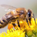
The wide-ranging biodiversity audit launched last summer is well underway, with habitats on both the Lancashire and Yorkshire Surveys mapped, identified and quantified. Carried out in partnership with Natural England and the Game and Wildlife Conservation Trust, the aim of the project is to identify, map, encourage, protect and preserve appropriate habitats for wild pollinators and other farm wildlife throughout the year and across all of the Duchy’s agricultural holdings.
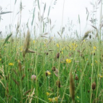
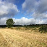
The first phase of the project focuses on investigation and documentation to identify and record the quantum, scale and condition of the diverse natural habitats which already exist across the estate. A database of all habitats and features present on the holdings will be created, including detailed reporting on hedgerows, overgrown historic boundary cams, field corners, wild bird mixes, pollen and nectar mixes, scrub, species-rich grassland, field margins, watercourses, ponds, and woodland.
Similar investigative work is now planned across the Cheshire, Staffordshire and Southern Surveys.
Commenting on the results to date, Christopher Sparrow, Head of Rural Estates at the Duchy, said: “As a responsible landowner, the Duchy is supportive of national ecological initiatives and is particularly interested in protecting wild and natural pollinators. We are grateful to our tenants for their support for the initiative and will be sharing the findings in due course to help them understand the habitats present on their farms and how these connect to one another to ensure a sustainable ecological balance across the estates.”
Once all of the relevant data has been compiled and mapped, an action plan detailing any further work required to protect, enhance and preserve these habitats will be drawn up for implementation in 2019/20.
